The Te Wāhipounamu UNESCO World Heritage Site has formed in the southwest corner of the south island of New Zealand. Yet again, we are to thank tectonic movement and multiple glacial runs for forming the 2.6 million hectares of pristine fjords, lakes, snow-capped peaks, rainforests, wetlands, and waterfalls off towering cliffs. The aptly named Te Wāhipounamu is a Māori word meaning “place of greenstone”, and it covers 10% of landmass of the three islands that make up New Zealand. The main mountain range in Te Wāhipounamu, the Southern Alps (Kā Tiritiri), are formed from 100-300 million-year-old sedimentary rocks, and they continue to be one of the world’s most rapidly rising mountain ranges. Currently, the range reaches peaks of around 13,000 feet, and at some points reach this altitude only 18 miles from the Tasman Sea to the west. As the largest mountain range in New Zealand, the Southern Alps are a product of a glorious, gradual collision between the Indo-Australian and the Pacific continental plates. This contact point of the two plates is known as the great Alpine Fault, and is one of only three plate boundaries in the world on land.
The heritage site is mostly mountainous terrain, however it is host to some of the world’s most unique flora. It is estimated New Zealand separated from Gondwana some 85 million years ago allowing it to maintain the best representation of the ancient plant life of the super-continent. Several flightless birds and countless fauna act as living evidence of this ancient biodiversity, and it is attributed to the separation of New Zealand before the appearance of mammals on Gondwana, as well as its consistent isolation thereafter. The region has several species of ancient flora varying from alpine beech trees to podocarp trees in the rainforests.
The only alpine parrot in the world, the kea, calls the mountains of Te Wāhipounamu home, and it has a reputation for being quite cheeky. This colorful, flightless bird has been known to pair up with a fellow kea to ransack tourists’ backpacks for food, while all that Te Wāhipounmau has to offer undoubtedly awes them. While the kea is not creating mischief, it commonly resides with a mate for life in the beech forests of Fiordland National Park. Other fauna include the kiwi, where New Zealander’s get their international alias, fur seals, yellow-crowned parakeet, and rock wrens.
In total, Te Wāhipounamu contains 23 different reserves varying from scientific, to private, to scenic. It is home to four national parks including Fiordland, Mount Aspiring, Mount Cook, and Westland. Furthermore, various protected public conservation areas border most areas providing effective isolation. In addition to the tallest mountain in New Zealand, Mt. Cook, Te Wāhipounamu consists of many lakes and 15 fiords including the “8th wonder of the world”, Milford Sound.
Conservation:
Due to its unprecedented beauty and accessibility, Milford Sound is one of New Zealand’s most popular tourist destinations located in Fiordland National Park. Milford Sound’s accessibility has come at a price to the wilderness integrity of Fiordland National Park, and has undeniably resulted in some controversy. There is only one route to Milford Sound on an alpine road that cuts directly through one of the final mountain divides with the Homer Tunnel before continuing on to Milford. The Department of Conservation (D.O.C.) acts as the caretaker of Te Wāhipounamu, and they are responsible for all maintenance and preservation of it for future generations. The D.O.C. can ensure the protection of this sacred heritage site under the National Parks Act of 1980 and the Conservation Act of 1987.
Most recently, the D.O.C. and those in favor of complete wilderness preservation have been opposing a 75-mile Haast-Hollyford Highway connecting Haast to Milford Sound. The “Zombie Highway” was first proposed in the 1860's solely for tourist purposes, and it is predicted to shorten travel time, reduce congestion on Milford Road, and boost the New Zealand travel economy by millions. Durham Havill, the sole shareholder ofHaast-Hollyford Highway Ltd, the company reviving the highway construction, claims the project will cost around $250 million, however experts have estimated the costs no less then $1 billion. Other than obvious infringements on the landscape the highway is planned to cut through, it would considerably reduce the size of the neighboring Olivine Wilderness Area and destroy the Hollyford Tramping Track completely. Perhaps the greatest risk of all in the construction of this highway is not the likely increase in number of pests to the area, or the failure to actively conserve a wilderness area, but maintaining status of the UNESCO World Heritage Site itself. There is no recovery for a wilderness area once it is dismantled and tarnished, and projects similar to this in other parts of the world have led to a reassessment of World Heritage status.
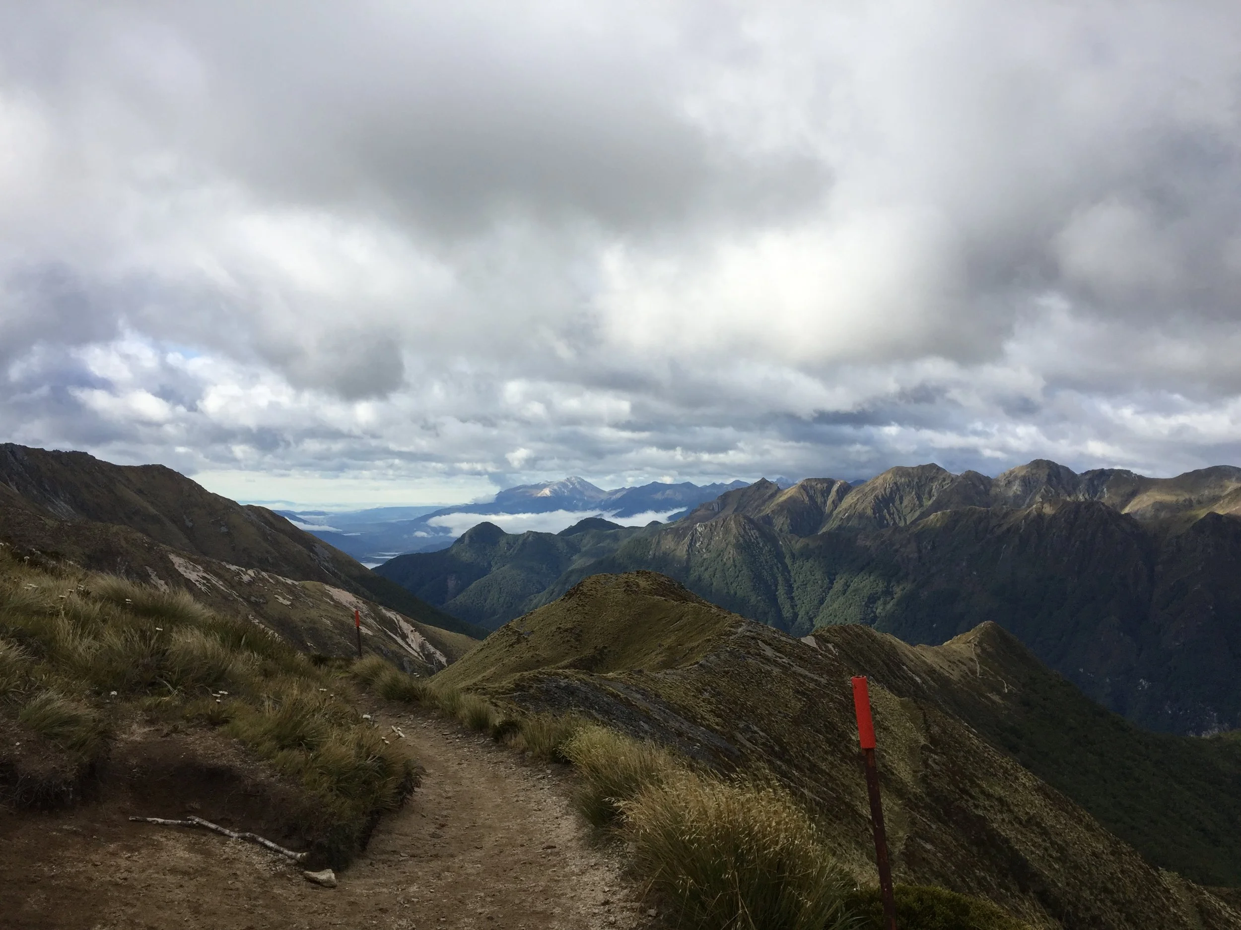
Other challenges looming over the sanctity of Fiordland National Park include managing the estimated 593,000 visitors to Fiordland alone, and preserving the natural quiet as a result of this popularity. The park offers a slue of tourist activities enveloping visitors within the tremendous landscape, including three great walks known as Kepler track, Milford track, and Routeburn track. Tourists can access these unforgettable great walks, or take a stroll through glowworm caves by using the lakeside town of Te Anau as a jumping off point. The small, lively town Te Anau is reachable by bus from any major city in the south island. At the heart of the town, silhouettes of massive mountain spines that host these great walks can be made out just beyond Lake Te Anau, the largest fresh water lake by volume in Australasia. The D.O.C. regulates the amount of visitors on each great walk every day, and only has a select number of campsite permits for each night, some of which are purchased 6-8 months in advance. The D.O.C. is quite stern that visitors camp only in the designated areas, and they also provide visitors with a basic hut option for some areas of the walks to reduce environmental impact.
In the Te Anua basin this year, tourists are expected to bring in $46 million per day, and DOC will have to manage this influx without any increase in their funding. Currently DOC receives around 0.5% of the national budget, and efficiently maintaining the 32% of landmass it is responsible for is a great challenge with perennial budget cuts every year. The health care industry spends the equivalent in around 10 days. As of June, 2016, DOC plans to increase tourism to conservation lands from 37% to 50% bringing the impact of around 1.2 million people to these protected lands. So, the perpetual problem of lack of funding is the double edged sword for DOC. Funding can be acquired through increased tourism to conservation areas and otherwise, however this undoubtedly increases the demands for every kind of conservation effort from DOC.
In addition, the only native land mammal in New Zealand is the bat, and the D.O.C faces challenges controlling foreign animal pests including rats, possums, and stoats for the protection of the native birds. Pest control is arguably D.O.C.'s largest and most pressing challenge, and their current strategies have met much opposition from the people of New Zealand. The main pest control strategy is the use of 1080 (fluoroacetate) in water soluble bait often dispersed via air drops over 440,000 hectares. In areas where 1080 is used on the west coast, research has shown four times as many kea chicks than previously documented. The chemical 1080 breaks down naturally in the environment and its use is responsibly managed by health and environmental regulations. Over 500 studies have been conducted over the last five years of various water sources, and researchers have yet to find harmful concentrations of 1080 in these areas of study. Nevertheless, the implementation of chemicals into a natural ecosystem does not go unimpeded. The Maori consider the forests their pataka, or pantry, and have expressed their concern 1080 unavoidably becomes part of their life giving streams, and the fish and eels that inhabit them. The forest is sacred to the Maori, and the effect of an intervention like 1080 is seriously considered. Furthermore, hunters have opposed the use of 1080 due to its accidental intake by deer, however DOC is beginning to use 1080 bait with deer repellent. Collectively, it is agreed pests present one of the most immediate problems to the integrity of forests all over the World Heritage Site. There is no doubt 1080 is effective, but with opposition and lack of funding, DOC can not currently focus enough resources to completely eradicate the pest problem of New Zealand. It is an ongoing battle, and there are countless 1080 success stories such as the protecting of the Kokako bird in the northern Pureora Forest. DOC continues their use of 1080 in projects such as Battle for the Birds and Project Kaka. Other major conservation accomplishments for the D.O.C. in recent years include the termination of electric generation using Lake Manapouri and Lake Wanaka, and sustained protection of podocarp rainforests.
Native Population:
Perhaps the most innovative and commendable practice the D.O.C. demonstrates in the protection of the heritage site is its collaboration with the Māori people; specifically the tangata whenua. The indigenous people of the land, the tangata whenua, have manawhenua (authority over the land), and have a legitimate influence on the management of this heritage site through annual meetings with the D.O.C. Through D.O.C. legislation it strives to uphold principles outlined in the Treaty of Waitangi to work with the indigenous people.
The Treaty of Waitangi in 1840 upholds the indigenous Māori people’s native right of "manawhenua" (authority over the land), and it passes generation to generation with the philosophy of "kaitiakitanga". All that is untouched, forbidden, and immaculate in Te Wāhipounamu can be linked back to Kaitiakitanga, a Māori word for guardianship, and the Māori have been guided by this philosophy for many generations. The principal Māori tribe in this region, the Ngãi Tahu, is intimately part of the land physically, culturally, and spiritually, and they still have a significant impact on the management of this heritage site. This ancestral philosophy of stewardship over the land translates into all New Zealanders, and it is evident by the conservation of Te Wāhipounamu.
Visiting:
The park offers a slew of activities enveloping tourists within the tremendous landscape including three great walks known as Kepler track, Milford track, and Routeburn track. Tourists can access these unforgettable great walks or take a stroll through glowworm caves by using the lakeside town of Te Anau as a jumping off point. The small, lively town Te Anau is reachable by bus from any major city in the south island. At the heart of the town, silhouettes of massive mountain spines that host these great walks can be made out just beyond Lake Te Anau, the largest fresh water lake by volume in Australasia. The D.O.C. regulates the amount of visitors on each great walk every day, and only has a select number of campsite permits for each night; some of which are purchased 6-8 months in advance. The D.O.C. is quite stern that visitors camp only in the designated areas, and they also provide visitors with a basic hut option for some areas of the walks to reduce environmental impact.
*Content and photographs provided by Brandon Zarichnak
References:
Department of Conservation - 1080 Pest Control
Fiordland Park Management Plan
Wilderness Within World Heritage: Te Wahipounamu, New Zealand
Federated Mountain Club of New Zealand Inc. (journal) . National Library, Wellingtong, NZL. Editor- Shaun Barnett.